Cool, Windy Weather

Peggy Paddling Up the CreekIt’s not unexpected that even Southern Florida has cold spells. Well last week was one of them. Mornings were cold in the 40’s and daytime highs barely reached the 60’s. But what was worse was the wind, at times reaching 40 mph. On those days we stayed inside but finally the wind stopped, and we got out paddle again.

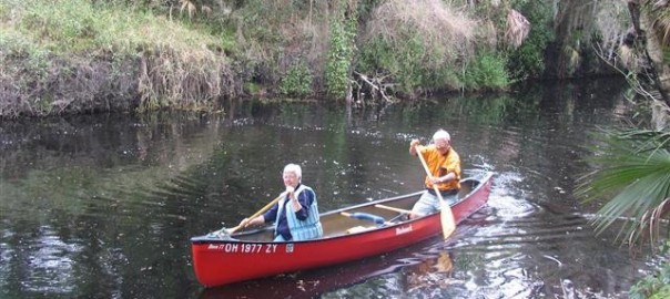
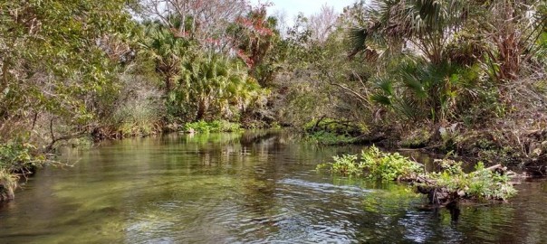
On Wednesday we got out in our canoe and paddled even further up Hickey’s Creek. The creek is much narrower and wilder beyond the little park that we got to last week. There are many low hanging branches and tight bends but has more wildlife. We paddled for 3-1/2 hours and even though it was only 60oF, it was sunny and I didn’t need a sweatshirt.

We saw a Alligator, a Limpkin, many Ibis and Egrets.

Franklin LockA few weeks ago they got 12” of rain in the counties around Fort Myers, but the rain had stopped by the time we got here. However, as we drove due south on the small local roads from Lithia Springs, all the farm fields were underwater. All this water is entering the Caloosahatchee River and has also filled Lake Okeechobee for the first time in a few years.

Boats in Franklin Lock


The local TV news people are going crazy; “It’s been terrible, all this brown water coming out of the river is ruining our beaches at Sanibel and Fort Myers. It’s all that dirty polluted water from that big bad lake”. Nothing could be further from the truth. First of all the lake is now full and whatever comes in must flow out. I guess the locals here just want the Lake to flood until the dam bursts. Don’t they realize this? Second, they are only releasing 5000 CFS from the dam into the river but here downstream at our campground there is 10,000 CFS passing through the lock. This means half the water is runoff from the record setting rainfall and of course with pine trees there is a brown color to the water along with the dirt and fertilizer runoff from the farms. Here at camp the water is brown colored but clear and the fishing is good.Out of the Lock


But they are still complaining on TV every day. They want this freshwater stopped, the salt water fish don’t like it and some die.

I noticed that NBC was videoing in our campground so I walked over to talk to the cute reporter. I found myself on the 6 O’Clock News that day. I videoed this using my cellphone from our TV, take a look.

John at Visitor CenterFor us to paddle the river upstream of the lock it’s easy to paddle across the river and portage through the Corps. picnic ground and lock viewing area. Yesterday we decided to stop and view the boats going through the lock and visit the Corp. visitor center. The photos above are a view of boats passing through the lock.

They say that Manatees also pass through the lock everyday and wait around until the lock opens each morning. The lock is only in operation from 7AM to 5PM. So boats wanting to traverse FL from Fort Myers to Stuart on the waterway must wait overnight here, if they get here too late in the day.

Today is our last day at Franklin Locks. We leave Saturday morning to travel along the river to the East Coast and the city of Lake Worth. We will stay for a week at John Prince Memorial Park. on Lake Osborn.

John Prince Park – Palm Beach County Park

jpp

This large park is just part of the Palm Beach County Park System. It is located in Lake Worth, FL. This is the Link to the park & campground.

The camp has over 300 small campsites, jammed in between a private airport and the lake. However it seems to be very popular and most of the sites are occupied for the entire winter season. 68 sites are limited to 14 day stays and they are all along the shore of Lake Osborne.

Prices are similar to Florida’s State Parks but they only take reservations 90 days in advance, so it is much easier planning and getting a campsite here.

Muscovy Duck looking to come in camper

We got here last Saturday morning and will stay for a week. We were welcomed by this Muscovy Duck who looked like we was ready to come into our camper. It was a good thing we had our screen door closed. These ducks seem to roam all around the campground looking for handouts.

The weather has been back to normal temperatures, 60-75oF for this time of year, except on Tuesday morning. We awoke to a severe thunderstorm which had tornado warnings for our location. In fact, 3 tornadoes touched down south of here. The storm was gone in an hour and we had an 80oF day.

What we like best are the paved bike trails, shown on the map above. It is about a 9 to 10 mile ride around the park and lake. The weather has still been windy and since we could see the entire lake from the bike ride, we saw no reason to try canoeing around the lake.

Wood StorksThere are birds everywhere who seem to have lost all fear of anyone on the trails. We saw large flocks of Ibis, many kinds of ducks, including the 3 Wood Storks above. Lots of Herons, Anhingas and Egrets. There are supermarkets not far off the trail where we can do a little shopping.

Our vacation plans after this are a little loose. We had figured by now we would want to go north  to Ocala National Forest where it would be cooler. But we really have not had any really warm weather yet, and Peggy didn’t want to go very far North already. We agreed we both liked Lithia Springs, south of Tampa and Silver Lake, north of Tampa and wouldn’t mind spending a week or so back in that area before going north to Ocala.

Lithia Springs 3rd time

Lake Okeechobee Trail ClosuresAfter spending a week in Lake Worth, we were ready to move on. The weather has been cool all of January & February, which is actually good for staying active. We did a lot of bike riding as I had discussed in my last blog but we wanted to canoe again.

Most of the Florida rivers are very wild and isolated but we felt maybe it was too early to head north to Juniper Springs. It is due east of Ocala. We decided instead to head back to Lithia Springs which is about 200 miles away.

Peggy on Hoover DikeWe decided to see if we could see Lake Okeechobee from a bike trail along the Hoover Dike. There is a trail entirely around the lake but see the map above, the Orange Lines are trail closures. So we picked the 5.6 mile section in Clewiston to ride since it was on our way to Lithia Springs. But even though there was a great big parking lot, the trail access in Clewiston was closed, so we drove to the more northerly trail access point and found out that we could bike about 4.5 miles each way along the dike. However all you could see were the canals on each side of the dike, it turns out there is a grass island at that point which limits your view of the lake.

Peggy & John CanoeingI rewarded Peggy with a Prime Rib dinner at a nice restaurant in Avon Park. Peggy got a haircut at a Super Wal-Mart and it was getting dark so we stayed overnight there.

We left early and went directly to the put-in at Alderman Ford where I dropped Peggy off with the canoe. I had called the campground host who graciously shuttled us the last time, to see if campsites were available. We missed our favorite site #40 but got another big site. They gave me a shuttle ride back to the Peggy and the canoe. The river was still running at a descent level, about 280 CFS. There were 6 or 7 little class 1 rapids. I can never slow Peggy down, we finished the 4 hour trip in 2-1/2 hours.

Peggy at Fishhawk Ranch Trail

On Monday we headed back on about a 10 mile ride through a new section of bike trails east of Fish Hawk Ranch. We had a few hills that Peggy didn’t like along the main road but it was a perfect day for biking.

We plan to stay here at least four more days.

Starting to head a little North–Cypress Glen Campground at Silver Lake

Map4We spent 10 days here (#5 on map) in early December December’s Blog and all three of their campgrounds were nearly empty.

We got here at 10 AM on Friday morning. If it wasn’t going to be a cool weekend I think the two Class A campgrounds would have been full.

We drove to the second campground which is still on the lake but further from the I-75 traffic noise. There were a few empty sites and we picked one with easy access to the lake, which is just a wide spot on the Withlacoochee River.Canoeing_Withlacoochee_wOur plan is to stay here for four nights and then, on Tuesday, go visit Helen & Paul who live just a few miles away in Inverness. We were going to visit them in December but it didn’t work out. We met them in Mexico where they camped at Xpu-Ha with us in 2013-14.

What we like about this complex is the big campsites with hookups for only $15/night, nice hiking trails, easy river access, and it is only 1 mile off the 46 mile long Withlacoochee State Trail, one of the longest paved trails in FL. Because this is a State Forest and doesn’t take reservations and limits camping to 14 days, travelers can usually get a campsite.

So even if it is cool there is still a lot to do. We took a short 10 mile bike ride on Friday and hike on Saturday. Sunday we plan to do some canoeing.

Juniper Springs–Ocala National Forest

Juniper Springs 2016

After leaving Silver Lake on Tuesday we went to visit our friends Helen & Paul Tempesta in Inverness, FL. Paul had a nice place for us to camp overnight and Helen cooked a great Lasagna dinner. We really enjoyed their warm hospitality.

We left their place around 7:30 AM with the thought of canoeing on Silver Springs along the way to our next four day stop at Juniper Springs in Ocala National Forest. We did some grocery shopping but then got anxious to get a campsite, so we skipped paddling for today. Whenever we are in Central FL, we try to camp here ever since our first visit 47 years ago. I found some of my old pictures to show how little the spring has changed and how much my family has changed over the years. They still keep this place really nice.

Our first Juniper Springs visit in 1969. Peggy with Pam 2 yrs and Jeff 5 yrs old.

Juniper Springs 1969 Juniper Springs 1975

Pam (7), Joan (4) & Jeff (10) swimming in the spring in 1975

Kobak Family Paddling 1976


Peggy, Joan, Jeff & Pam canoeing in 1976.

Juniper Springs-2 2016

Juniper Springs is a constant 72oF, which is too cold for swimming except on hot days. It is the source of the river we canoed on Thursday.

In the past I did my own bike shuttle but FL40 & US19 now have a lot of very fast traffic and the park canoe concession does shuttles for only $10. You first drop off your canoe at the put-in. You then pay and drive your vehicle at 8:30, 9:30, 10:30 or 11:30AM, they follow your there and bring you back to the put-in to start your trip. They have an option to bring your canoe and people back without a shuttle, but you must be at the take-out at specific times and the cost is $10 per boat plus $10 per person. I liked having the RV at the take-out when we finished.

Juniper Run - 1

Juniper Run is 7 miles long and when it starts at the spring is no wider than a canoe and it moves with a good current through a very isolated area. Other springs along the way add more flow and the last two miles the river broadens to a meandering swamp where gators and large birds are normally abundant.

Barred Owl FrontThis year we saw dozens of large turtles who had little fear of boaters. We saw this great big Barred Owl right at the start. but only one small gator.

Juniper Run - 2There are a lot of low hanging trees and shallow logs in the river which gives you a real workout maneuvering around all the obstacles.

We passed at least 12 other canoes and kayaks along the way. I’d hate to see what the weekend river traffic would be like when all the rental canoes are on the river. They do not recommend that novice paddlers even attempt the river and I sure agree. The river is very wild and scenic the entire way. See a typical view below.

Juniper Run - 3

It took us about 2-1/2 hours to paddle the river without any rest stops. I would guess it is normally a 4 hour trip for most paddlers. Near the end of the run there is actually a little rapid that they say appeared there about 3 years ago.

There is no Wi-Fi or even cell service in the campground. On one of the trails I got a weak phone signal but won’t be able to post this story until I can connect again to the internet.

Ocean Pond Our Last Florida Campground

Map-5

On Sunday morning we leave Juniper Springs. If the weather is good our plan is to drive to Silver Springs State Park and paddle the 5 mile long Silver River from a small marina up to the source of the spring where all the glass bottom boats are.

Over the years we have always enjoyed this run, especially with our kids when there were wild monkeys along the way. There is lots of wildlife since it is now in a protected State Park.

Later in the day we hope to make it up to Ocean Pond Campground in Osceola National Forest. We camped here on the way south over Thanksgiving and it was very full. We hope that on a Sunday, we will be able to get a campsite with electric power.

We will then start watching the weather up North and plan to take three days to make it home from here. We will start on I-10 to I-95 and I-26 which will bring us to I-77 our route home. See the map on the left.

Monkeys at Siver River

We made it to the marina to launch our canoe for our paddle up the Silver River to the source of the Springs by 8:30 AM Sunday morning.

We were on our way upstream by 9 AM. It is a 5 mile paddle  against a strong current and it took us 2 hours. About 1-1/2 miles up from the put-in we saw a big group of monkeys along the river that were introduced when they were making a movie here 50 years ago. Despite attempts to remove them they still seem to be surviving just fine.

Silver Springs

There was still all sorts of birds, turtles and a few alligators and the concession still looked the same but there were very few glass bottoms boats and no jungle cruise.

What we did notice was that there were all sorts of rental kayaks near the head of the spring.

The biggest change was there was no more nice white sandy bottom and there was all sorts of sea grass in the water and lots of algae. It is not nearly as pretty as it used to be.

It took us a little over an hour to paddle back downstream and we were on our way by 12:30 and got to Ocean Pond by 3:30, only to find out that we just missed the last site with electric hook ups and there was only a couple of other sites available.

However on Monday morning several electric sites became available. Now we just have to decide when we will head for home.

Olustee Battlefield Historic State Park

Ocean PondOcean Pond is a 2 mile in diameter lake with the campsites along the North shore. Here we are, packed up for our last night in Florida.

Ocean Pond Last Day

Olustee Battlefield Memorial1a

On our last day here we decided to take a bike ride over to the Historic Battlefield. It is only 4-1/2 miles by bike from our campsite and it is well worth the visit.

SoldierThey have a small museum that shows a film with a good explana-tion of the battle that the Union should not have fought and ended up losing because of their incompetence. There were 2800 casualties and nothing was accomplished that mattered in the war.

Olustee Battlefield Memorial2

There is a big reenactment of the battle every February, but today we were the only visitors.

Heading Home a Little Earlier This Year

Finally the weather turned warm and dry for us, so what do we do? That’s right, we plan to head home to take advantage of the warm weather forecast for NE Ohio. Our plans could change if the weatherman lets us down, but right now it looks like it would be good for unpacking our RV at home with the temperatures in the 60’s.

This means we would want to get home by Friday night 3/11 or Saturday morning. To allow a leisurely drive home, we will leave our campground here at Ocean Pond on Wednesday morning. We hope to be in SC on Wednesday night and in WV on Thursday night.

Back Home on Friday Morning 3/11

It has been pointed out to me that I never finished my blog for this year’s winter trip.

First, the drive home went as planned. We always watch the weather carefully and decided to come home a little early to take advantage of the beautiful warm, 80oF weather for the rain free drive home.

We overnighted at Wal-Mart’s in Columbia, SC and S. Parkersburg, WV, and were home by 10:30 AM on Friday. We had warm weather to unpack when we got home. We were totally unpacked by Friday night.

Peggy-John

Peggy and John Somewhere on the Trail

56th Anniversary

As you can see, we clean up well.

It was great trip, we stayed in beautiful campgrounds with lots to see and do.
It was much different than our Mexico trips and I’m sure it was less expense.

Now, being an engineer, here is:

Our Trip by the Numbers

The total trip duration was 121 days but we were home for the holidays for 17 days.
We drove 3700 miles, spending $725 for gas, averaging about 9.2 mpg.
Considering the days at home, friend days and Wal-Mart nights as zero camp cost our average camp cost was only $15/night.
We paid as high as $39/night at the only private campground on Jekyll Island.
We paid as low as $8/night at Ocean Pond Campground with no electric hookups.
We canoed on 8 different rivers for a total of about 140 miles.
We biked a total of over 250 miles.

This is my last Blog for the season.

If this is the first time that you are visiting our Florida Blog you may want to click this to read about our trip in Chronological Order rather than going backwards from the present day to trip start.